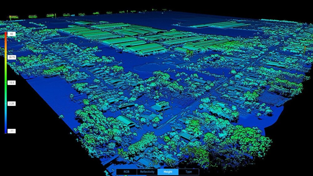
New Trimble R12i fitted to an UltraTEM-IV metal detector for unexploded ordnance (UXO) detection at the LXML Sepon mine site in Laos. Michael Laneville, Senior Geophysicist, LXML UXO Department, said “we were clearing UXO with different types of equipment depending on soil properties. “This placed restrictions on mining below 1.25m... read more →
Apr
03
Jun
02
Aruna Technology was engaged by Asia Svay Rieng Water to conduct an aerial survey by drone of 4,900 Ha in Bavet, Svay Rieng Province Cambodia. Additionally, we identified and mapped households by field survey who would be customers in the water supply network. The main purpose of the project was... read more →
Apr
01
In this tutorial, we will show you how to: Create a free ArcGIS Developer AccountDownload and install ArcGIS ProCreate and publish a web map to ArcGIS Online using Cambodia data All for FREE! To get started, download our tutorial here: Download PDF If you have any questions, please email SUONG... read more →
Dec
09
Reason # 1: Spend less time on-site As the guide below proves, when flying a 100 ha (247 ac) mapping project, a fixed-wing senseFly eBee X drone can complete this job in 26 minutes, a saving of 22 minutes over a typical quadcopter system. Expand the project size further, up... read more →
Sep
19
Launched with the promise that “it’s not about the drone,” but instead about overcoming business challenges, the eBee X, part of the Parrot Business Solutions portfolio, is designed to boost the quality, efficiency and safety of an operator’s geospatial data collection. It offers a camera to suit every job, the accuracy and... read more →
Mar
21
In case you've found ArcGIS Server configuration options confusing, here is a diagram of some basic configurations for an entry level ArcGIS Server setup. Any questions or comments ? Please Contact Us for more info.
Sep
05
These instructions show you how to simply pan-sharpen Landsat 8 imagery using ArcGIS 10. The imagery is available for free from the USGS. នេះជាសេចក្ដីណែនាំ បង្ហាញអ្នកអំពីរបៀប នៃការធ្វើ pan-sharpen លើ Landsat 8 ដោយប្រើប្រាស់ កម្មវិធី ArcGIS 10 ។ រូបភាពទាំងនេះមាននៅក្នុង USGS ដោយមិនគិតថ្លៃ។ 1. After you have downloaded the imagery, add bands 4,3 and 2... read more →
Jan
17
The Royal University of Agriculture's department of Land Management and Land Administration, were the recipients of 3 complete sets of GNSS survey equipment, donated by Trimble and Aruna Technology. The equipment will allow the extension of teaching to include current GNSS survey techniques, in addition to the optical survey techniques... read more →
Dec
10
This image shows the extent of the reservoir of the recently completed Kamchay hydropower project. The image is from the dry season 2012 (May) so the reservoir is not yet at full capacity. Expected maximum water level is 175m, somewhere between the 160 and 180m contours shown in this map.Note... read more →
Dec
10
Interesting satellite image showing the extent of the Bokor Mountain development in Cambodia, which is still under construction.
Nov
08
There still exists some confusion about how we can work with topology in ArcGIS since workstation ArcINFO was discontinued some years back. So as a quick refresher, here is how we can work with topology in ArcGIS. នៅតែមានការយល់ច្រឡំអំពីរៀបធ្វើការជាមួយ topology នៅក្នុងកម្មវិធី ArcGIS តាំងតែកម្មវិធី ArcInfo ផ្អាក់ការផលិតជាច្រើនឆ្នាំមក ហើយ។ ដូចជាមានការបង្កើតឡើង នូវកម្មវិធី topology នេះជារបៀបដែលយើងអាចធ្វើការជាមួយនិង topology... read more →
Nov
02
These statistics are calculated from daily satellite observations and are useful for planning imagery acquisition.December to February are clearly the best months, but it is interesting to note that the late wet season (Nov) is better than April-May, though of course flood waters are still up in November. [caption id="attachment_793"... read more →
Sep
14
Three days after being orbited, SPOT 6 has delivered its first images Astrium Services has posted the first images from the SPOT 6 satellite, just three days after its launch on 9 September. SPOT 6 will assure continuity of data from the series of satellites operating since 1986, along with... read more →
Aug
29
With the advent of newer earth imaging satellites with daily overpass and capture possibilities, it is now even easier to monitor land use change. For example, we can examine the history of development of two Economic Land Concessions (ELCs) inside the Beng Per Wildlife Sanctuary. The concessions were granted in... read more →
Aug
24
Well I've finally manged to get my hands on some SPOT DEM data for Cambodia for a project in the Southern Cardamoms. Quite an improvement over the SRTM (90m) data. The SPOT DEM has a resolution of 30m at the equator. From Astrium: A SPOT DEM is a digital elevation... read more →