Aruna Technology Ltd Aruna Technology Ltd
  • Products
    • eBee Drones
    • Garmin GPS
    • Garmin Map
    • GIS Software
    • Satellite Imagery
    • Trimble Survey Equipment
    • Haglöf Forest Inventory Solutions
  • Solutions
    • Forest & Land Cover Mapping
    • GIS Consultancy
    • Land Survey
    • Remote Sensing and Image Processing
    • Training
    • Web GIS
    • REDD and Forest Carbon
  • Who We Are
  • About Us
  • Blog
  • Contact
Sep 14

SPOT6 Satellite – First Pictures

  • September 14, 2012
  • No Comments
  • Site News
Three days after being orbited, SPOT 6 has delivered its first images

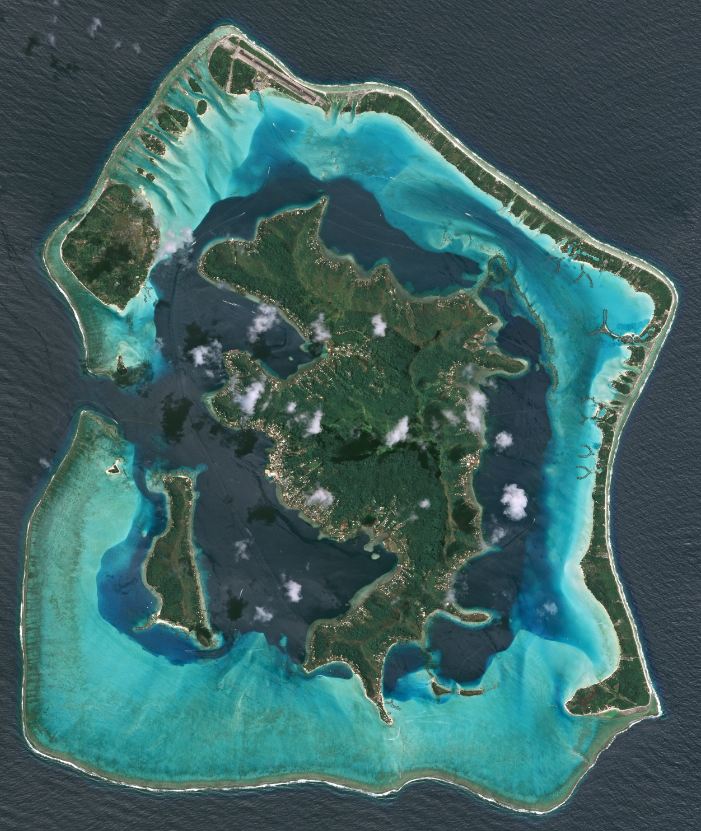
Astrium Services has posted the first images from the SPOT 6 satellite, just three days after its launch on 9 September.

SPOT 6 will assure continuity of data from the series of satellites operating since 1986, along with many technological innovations. Its unique responsiveness and acquisition capacity are set to benefit a broad spectrum of operational applications.

These first images present very varied landscapes, highlighting SPOT 6’s potential for applications like urban and natural resource mapping or agricultural and environmental monitoring. The wide imaging swath (60km), identical to that of the other SPOT satellites, makes SPOT 6 an ideal tool for covering vast territories, while its 1.5m resolution – against 2.5m on SPOT 5 – enables it to distinguish smaller features than ever before.

To post the images, all operational systems swung smoothly into action, from satellite tasking to image acquisition, reception and processing.

In January 2014, the arrival of SPOT 7 will bring more new services including daily revisits. Together, the SPOT 6 and SPOT 7 constellation will assure continued availability of high-resolution, wide-area products through to 2024.

Source: Astrium

Bora Bora (c) Astrium Geoinformation Services


Bora Bora Detail

  • Facebook
  • Twitter
  • Reddit
  • Pinterest
  • Google+
  • LinkedIn
  • E-Mail

About The Author

Leave a reply

Your email address will not be published. Required fields are marked *

SEARCH

Archives

  • April 2020
  • December 2019
  • September 2018
  • March 2014
  • September 2013
  • January 2013
  • December 2012
  • November 2012
  • September 2012
  • August 2012
  • June 2012
  • May 2012
  • April 2012
  • February 2012
  • November 2011
  • October 2011
  • September 2011
  • July 2011
  • June 2011
  • May 2011
  • April 2011
  • February 2011
  • January 2011
  • December 2010
  • November 2010
  • April 2010

Recent Comments

  • sathya LENG on Historical Maps of Phnom Penh
  • Maps of South East Asia | Walking in the Footsteps of Chang Noi on Garmin Map
  • sky on Using Khmer Unicode font with ArcGIS 10
  • Phalla Din on Equipment Donation to RUA
  • Phil on SPOT vs. SRTM DEM Comparison
© Aruna Technology. All rights reserved.