Aruna Technology Ltd Aruna Technology Ltd
  • Products
    • eBee Drones
    • Garmin GPS
    • Garmin Map
    • GIS Software
    • Satellite Imagery
    • Trimble Survey Equipment
    • Haglöf Forest Inventory Solutions
  • Solutions
    • Forest & Land Cover Mapping
    • GIS Consultancy
    • Land Survey
    • Remote Sensing and Image Processing
    • Training
    • Web GIS
    • REDD and Forest Carbon
  • Who We Are
  • About Us
  • Blog
  • Contact
May 03

Managing GPS Data

  • May 3, 2011
  • 4 Comments
  • Site News

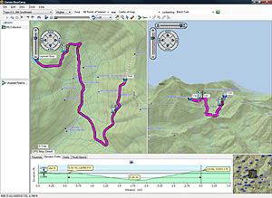
With the recent introduction of several new models such as the 62s ans 78s, you’ll also need to update your software to Basecamp, as Mapsource is no longer supported by these models. Basecamp is available as a free download from the Garmin Website and has extended functionality, such as photo geo-tagging and satellite image management (with a Garmin BirdsEye account). The full features of basecamp are:

  • View 24K or 100K topographic maps and other topographic data.
  • Displays maps in 2-D or 3-D, including elevation profiles.
  • View and rotate maps at any angle.
  • Create waypoints and routes on your computer and transfer maps, waypoints, routes, tracks and geotagged photos between your computer and device.
  • Transfers satellite images to your device (with the purchase of BirdsEye™ Satellite Imagery subscription).
  • Shows animated playback of routes and tracks over time.
  • Supports geotagged photos.
  • Easily organize data into folders.
  • Prints full-page, color maps.
  • Exports user data for viewing in Google Earth™.
  • Includes advanced geocaching support; can import data from geocaching.com.

Basecamp Screenshot

Garmin Basecamp

  • Facebook
  • Twitter
  • Reddit
  • Pinterest
  • Google+
  • LinkedIn
  • E-Mail

About The Author

4 Comments

  1. Roy Gatchalian
    May 17, 2011 at 6:57 pm ·

    I have downloaded BaseMap 313 but it doesnt insttall into WINDOWS 7 X64. Any suggestions please. I got an Oregon 450. Thanks a ton

  2. Touch Borith
    May 31, 2011 at 10:18 am ·

    I would like to quot this important GPS Map 60 and need some information data for briefing to my staffs.

  3. Touch Borith
    May 31, 2011 at 10:19 am ·

    please provide new modeling GPS62,..etc.

  4. admin
    June 7, 2011 at 6:04 pm ·

    Hi,

    We’ve not tried it and the Garmin website does not specifically mention it, only that “IBM-compatible PC running Windows XP Service Pack 3 or later operating system.”

    Paul

Leave a reply

Your email address will not be published. Required fields are marked *

SEARCH

Archives

  • April 2025
  • June 2024
  • April 2020
  • December 2019
  • September 2018
  • March 2014
  • September 2013
  • January 2013
  • December 2012
  • November 2012
  • September 2012
  • August 2012
  • June 2012
  • May 2012
  • April 2012
  • February 2012
  • November 2011
  • October 2011
  • September 2011
  • July 2011
  • June 2011
  • May 2011
  • April 2011
  • February 2011
  • January 2011
  • December 2010
  • November 2010
  • April 2010

Recent Comments

  • sathya LENG on Historical Maps of Phnom Penh
  • Maps of South East Asia | Walking in the Footsteps of Chang Noi on Garmin Map
  • sky on Using Khmer Unicode font with ArcGIS 10
  • Phalla Din on Equipment Donation to RUA
  • Phil on SPOT vs. SRTM DEM Comparison
© Aruna Technology. All rights reserved.