Aruna Technology Ltd Aruna Technology Ltd
  • Products
    • eBee Drones
    • Garmin GPS
    • Garmin Map
    • GIS Software
    • Satellite Imagery
    • Trimble Survey Equipment
    • Haglöf Forest Inventory Solutions
  • Solutions
    • Forest & Land Cover Mapping
    • GIS Consultancy
    • Land Survey
    • Remote Sensing and Image Processing
    • Training
    • Web GIS
    • REDD and Forest Carbon
  • Who We Are
  • About Us
  • Blog
  • Contact
Jan 17

Equipment Donation to RUA

  • January 17, 2013
  • 1 Comment
  • Site News

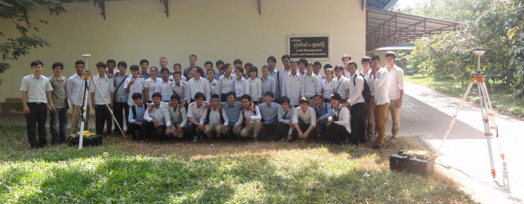
The Royal University of Agriculture’s department of Land Management and Land Administration, were the recipients of 3 complete sets of GNSS survey equipment, donated by Trimble and Aruna Technology. The equipment will allow the extension of teaching to include current GNSS survey techniques, in addition to the optical survey techniques currently taught at the department. Present at the hand over ceremony, pictured below are Paul Gager, Technical Director at Aruna Technology, Vung Setha , Dean of the department of Land Management and Land Administration and a class of enthusiastic students studying at the undergraduate level.

Photo 2

  • Facebook
  • Twitter
  • Reddit
  • Pinterest
  • Google+
  • LinkedIn
  • E-Mail

About The Author

1 Comment

  1. Phalla Din
    March 10, 2015 at 12:34 pm ·

    I am looking for help in getting aerial photographs of our small farm in kohkrolar district, battambang province, Cambodia. 089 491 174….thank you. Phalla

Leave a reply

Your email address will not be published. Required fields are marked *

SEARCH

Archives

  • April 2025
  • June 2024
  • April 2020
  • December 2019
  • September 2018
  • March 2014
  • September 2013
  • January 2013
  • December 2012
  • November 2012
  • September 2012
  • August 2012
  • June 2012
  • May 2012
  • April 2012
  • February 2012
  • November 2011
  • October 2011
  • September 2011
  • July 2011
  • June 2011
  • May 2011
  • April 2011
  • February 2011
  • January 2011
  • December 2010
  • November 2010
  • April 2010

Recent Comments

  • sathya LENG on Historical Maps of Phnom Penh
  • Maps of South East Asia | Walking in the Footsteps of Chang Noi on Garmin Map
  • sky on Using Khmer Unicode font with ArcGIS 10
  • Phalla Din on Equipment Donation to RUA
  • Phil on SPOT vs. SRTM DEM Comparison
© Aruna Technology. All rights reserved.