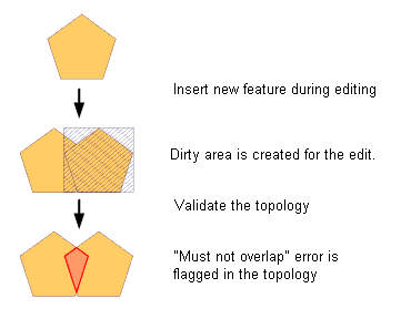
There still exists some confusion about how we can work with topology in ArcGIS since workstation ArcINFO was discontinued some years back. So as a quick refresher, here is how we can work with topology in ArcGIS.
នៅតែមានការយល់ច្រឡំអំពីរៀបធ្វើការជាមួយ topology នៅក្នុងកម្មវិធី ArcGIS តាំងតែកម្មវិធី ArcInfo ផ្អាក់ការផលិតជាច្រើនឆ្នាំមក ហើយ។ ដូចជាមានការបង្កើតឡើង នូវកម្មវិធី topology នេះជារបៀបដែលយើងអាចធ្វើការជាមួយនិង topology កម្មវិធី ArcGIS ។
What is Topology ?
តើ Topology គឺជាអ្វី?
In geodatabases, topology is the arrangement that defines how point, line, and polygon features share coincident geometry. For example, street centerlines and census blocks share common geometry, and adjacent soil polygons share their common boundaries.
នៅក្នុង geodatabases, កម្មវិធី topology គឺជាអ្នករៀបចំនឹងកំណត់អោយបានច្បាស់លាស់នូវ point, line និង polygon ដែលកើតមានឡើងតំណាល់គ្នាតែម្តង។ ឧទាហរណ៌ ដូចជាចំណុចកណ្តាលនៃទ្រូងផ្លូវ និងទិន្ន័យអំពីប្រជាជនទៅ តាមតំបន់និមួយៗ ហើយនិងធ្វើការរៀបចំដីថ្លីរបស់ពួកគេទៅតាមព្រំប្រទល់ដី។
To create a with a topology, you will need at a minimum:
ការបង្កើត topology អ្នកត្រូវការកម្មវិធីដូចជា:
- ArcGIS Desktop Standard or Advanced Software (fomerly ArcEditor and ArcInfo)
- កម្មវិធី ArcGIS Desktop Standard ឬ Advanced (ArcEditor និង ArcInfo)
- A multi-user Geodatabase. You can start with SQLServer Express (Free)
- ការប្រើប្រាសច្រើនក្នុងពេលតែមួយ អ្នកអាចប្រើជាមួយកម្មវិធី SQLServer Express
- A feature dataset containing in the Geodatabase one or more feature classes
- ក្នុង feature dataset និមួយៗ ដែលមាន feature classes មួយ ឫក៌ច្រើននៅក្នុង Geodatabase
Steps:
ជំហាន:
- If you already have some data whose topology needs to be checked, you should load that data into the feature dataset to create a new feature class. A feature dataset is basically a container, holding one or more feature classes. One feature class would normally represent one kind of thematic feature, e.g. soil polygons, road lines etc.បើសិនជាអ្នកមានទិន្ន័យខ្លះ ដែលត្រូវការពិនិត្យក្នុង topology អ្នកត្រូវតែដាក់បញ្ចូលវាទៅក្នុង feature dataset ដែលបានបង្កើត feature class ថ្មី ។ feature dataset ជាកន្លែងផ្ទុកដំបូងគេ ជាចំណែកមួយ ឬច្រើននៃ feature classes ។ Feature class មួយតំណាងអោយមួយប្រភេទនៃ thematic feature ។ ឧទាហរណ៌ ដូចជាទ្រង់ទ្រាយដី និងរូបរាងផ្លូវ ។
- Once you have a feature class loaded, you need to define a topology rule using ArcCatalog. Topology rules define the permissible spatial relationships between features. e.g. “Must not overlap” and are stored in the feature dataset. You also need to specify which feature class or classes the topology rule applies to.ពេលដែលអ្នកបញ្ចូល feature class អ្នកត្រូវធ្វើវាទៅច្បាប់របស់ topology ដោយប្រើកម្មវិធី ArcCatalog ។ ច្បាប់របស់ Topology ត្រូវអោយបង្ហាញអោយបានច្បាស់រវាងទំនាក់ទំនងរបស់ features ។ ឧទារណ៌ មិនអនុញ្ញាតអោយត្រួតស៊ី “Must not overlap” និងរក្សានៅក្នុង feature dataset ។ អ្នកត្រូវបញ្ចាក់អោយច្បាស់លាសទៅលើ feature class ណាមួយ ឬទៅលើប្រភេទរបស់ topology ដែលបានកំណត់ ។
- The next step is to validate the topology, which checks all features to see if they meet the topology rules. You can validate topology in ArcMap (while editing) or in ArcCatalog.ជំហានបន្ទាប់គឺការវាយតម្លៃរបស់ topology, ត្រួតពិនិត្យរាល់ features ថាតើគោរពទៅតាមច្បាប់របស់ topology ឬក៌អត់។ អ្នកអាចធ្វើការវាយតម្លៃ topology ក្នុងកម្មវិធី ArcMap (អំឡុងពេលដែលកំពុងប្រើប្រាស់វា) ឬ ArcCatalog ។
- Correcting the errors can be done one by one in ArcMap using the error inspector. You can right-click the error in the list or on the map and click one of the available fixes. The fixes listed depend on the type of error.ធ្វើការកែរកំហុសអោយបានត្រឹមត្រូវម្តងមួយៗ នៅក្នុងកម្មវិធី ArcMap ដោយប្រើប្រាស់ឧបករណ៌ error inspector ។ អ្នកអាចចុច Mouse ខាងស្តាំ ទៅលើកន្លែងដែលមានកំហុសក្នុងតារាង ឬនៅលើផែនទី និងចុចមួយដងទៅលើឧបករណ៌ជួសជុល ។ ការជួសជុលអាស្រ័យទៅលើប្រភេទដែលមានកំហុស ។
You can read more about creating and managing database topologies here;
អ្នកអាចអានបន្ថែមទៀតអំពីរបៀបនៃការបង្កើត និងរបៀបនៃការរៀបចំទិន្ន័យនៅក្នុង topologies នៅទីនេះ ។
http://help.arcgis.com/en/arcgisdesktop/10.0/help/index.html#/Topology_in_ArcGIS/006200000003000000/
For more advanced users, it is also possible to automate some topology fixes using geopreocessing tools and Model Builder in ArcMap. e.g.
សម្រាប់ការប្រើប្រាសដែលមានកំរិតខ្ពស់ វាជាភាពងាយស្រួលដោយស្វ័យប្រវត្តិខ្លួនឯងខ្លះៗទៅលើការជួសជុល topology ដោយប្រើប្រាស geopreocessing និង Model Builder ក្នុងកម្មវិធី ArcMap ។
http://blogs.esri.com/esri/arcgis/2011/11/15/cleaning-up-line-data-with-geoprocessing/


