Aruna Technology Ltd Aruna Technology Ltd
  • Products
    • eBee Drones
    • Garmin GPS
    • Garmin Map
    • GIS Software
    • Satellite Imagery
    • Trimble Survey Equipment
    • Haglöf Forest Inventory Solutions
  • Solutions
    • Forest & Land Cover Mapping
    • GIS Consultancy
    • Land Survey
    • Remote Sensing and Image Processing
    • Training
    • Web GIS
    • REDD and Forest Carbon
  • Who We Are
  • About Us
  • Blog
  • Contact
Feb 12

Free Satellite Imagery of Cambodia

  • February 12, 2012
  • No Comments
  • Site News

Recent announcement from USGS:

OrbView-3 satellite images collected around the world between 2003 and 2007 by Orbital Imaging Corporation (now GeoEye) at up to one-meter resolution can now be downloaded at no cost through USGS EarthExplorer.

“This is a significant addition to the USGS archive and a valuable resource for the global science community,” said Matthew Larsen, Associate Director, Climate and Land Use Change. “Free access through the USGS archive amplifies the utility of the data, making it feasible for many researchers to study large areas at this level of accuracy.”

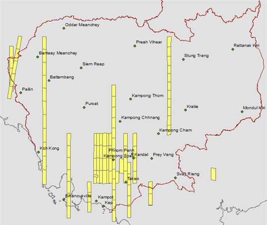
I took a quick peek at what is available for Cambodia (see graphic below). Would be nice to have more I suppose, but hey, better than nothing.

Orbview-3 Coverage Available for Cambodia


  • Facebook
  • Twitter
  • Reddit
  • Pinterest
  • Google+
  • LinkedIn
  • E-Mail

About The Author

Leave a reply

Your email address will not be published. Required fields are marked *

SEARCH

Archives

  • April 2025
  • June 2024
  • April 2020
  • December 2019
  • September 2018
  • March 2014
  • September 2013
  • January 2013
  • December 2012
  • November 2012
  • September 2012
  • August 2012
  • June 2012
  • May 2012
  • April 2012
  • February 2012
  • November 2011
  • October 2011
  • September 2011
  • July 2011
  • June 2011
  • May 2011
  • April 2011
  • February 2011
  • January 2011
  • December 2010
  • November 2010
  • April 2010

Recent Comments

  • sathya LENG on Historical Maps of Phnom Penh
  • Maps of South East Asia | Walking in the Footsteps of Chang Noi on Garmin Map
  • sky on Using Khmer Unicode font with ArcGIS 10
  • Phalla Din on Equipment Donation to RUA
  • Phil on SPOT vs. SRTM DEM Comparison
© Aruna Technology. All rights reserved.