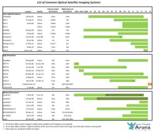
Aruna Technology Ltd can supply satellite imagery from any satellite sensor, past or present in Cambodia and Laos. Whether it be a historical analysis of land cover or an up-to-the- minute city view, we can meet your imaging needs.  We are authorised distributors of Digital Globe (WorldView, GeoEye and IKONOS), RapidEye and SPOT satellite imagery and can acquire any other imagery on your behalf.

We also offer comprehensive image processing services, including ground control point (GCP) collection, image ortho-rectification, radiometric correction and pan-sharpening. Our image analysis services include image segmentation and classification, DEM production from stereo pairs, mosaics and feature extraction.

Very High Resolution (VHR) Satellites

Newer VHR Satellites include WorldView-3 (0.31m), WorldView-2 (0.46m), GeoEye-1 (0.46m) and Pleiades.  These satellites generally have a higher collection capacity and image accuracy (to ground) is better than the older VHR satellites. Previous US government restrictions on better than 50cm imagery have been lifted and imagery can be ordered at native resolution. It’s impotant to note that these resolutions apply when the satellite is “at nadir” (pointing straight down). Some satellites have point up to 30 degrees off nadir, which has the effect of slightly reducing the effective resolution. The benefit of being able to point off nadir, however, is that the satellite can image areas more quickly on a particular pass.

Older VHR Satellites include WorldView-1 (0.46m), Quickbird (0.65m) and IKONOS (0.82m). WorldView-3 is panchromatic (black and white).

For more information or a quotation, please Contact Us.

GeoEye-1 Image, Banteay Chhmar, Cambodia
Pleiades Image, Vientiane, Laos. Click to download.

High Resolution (HR) Satellites

SPOT6/7 – The pair of identical satellites SPOT6 and SPOT7 will provide a daily revisit everywhere on Earth, with a total coverage of 6 million km² per day. SPOT-6 and 7 will have a service life of 10 years.  SPOT6 and 7 have a 1.5m panchromatic sensor and a 6m multi-spectral sensor with bands in the Blue, Green, Red and Near-infrared spectrum. A pan-sharpened color image with resolution can also be ordered.

RapidEye – The RapidEye satellite system comprises 5 satellites, launched on August 29 2008 to provide unparalleled coverage and resolution. The constellation has the capacity to image an area the size of India every day (4 millions sq km). RapidEye has a ground sample distance (GSD) of 6.5m and is delivered with a 5m cell size.

For more information or a quotation, please Contact Us.

RapidEye Image, Laos PDR. Click to download.
SPOT6 Image, Kandal Province, Cambodia

Satellite Image Launch History

Satellite Image Launch History

Click for full versions